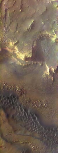
 Five years after leaving Florida for Mars, NASA's Mars Odyssey spacecraft is still orbiting the red planet, collecting scientific data and relaying communications from NASA's two Mars rovers to Earth. Images such as this spectacular, color view of sun-bathed, layered escarpments and wind-scalloped, basalt dunes in the solar system's largest canyon continue to beckon space explorers and guide the way for future missions. Basaltic dunes are common on Mars but rare on Earth. Rounded knobs and mesas on the canyon floor are reminiscent of desert geology in the southwestern U.S.
A team led by Phil Christensen, principal investigator for Odyssey's cameras at Arizona State University, Jim Bell at Cornell University, and space artist Don Davis created this panorama. They added color to radiance files from the Thermal Emission Imaging System (THEMIS), a camera on Odyssey that takes images in both the visible and infrared parts of the spectrum. They correlated the radiance - intensity of reflected sunlight - with that of other color images from Mars and mimimized the effects of residual scattered light in the images.
In addition to producing images such as this, Mars Odyssey has made global observations of Martian climate, geology, and mineralogy. The spacecraft's Gamma Ray Spectrometer has allowed scientists to make maps of the elemental distribution of hydrogen, silicon, iron, potassium, thorium, and chlorine on the Martian surface. A global map of minerals associated with water, essential to life as we know it, guided NASA in its selection of Meridiani Planum, the landing site for NASA's Opportunity rover, an area rich in hematite. Odyssey is currently supporting landing site selection for the Phoenix Scout Mission, to be launched in 2007, using data showing that surface areas near the poles of Mars consist of more than 50 percent water ice by volume.
Other Odyssey accomplishments include measurement of radiation, a prerequisite for future human exploration because of its potential health effects, and a groundbreaking program in education outreach that has allowed students to take pictures of Mars and conduct scientific investigations with cameras on Odyssey.
Mars Odyssey was launched April 7, 2001 on a Delta II rocket from Cape Canaveral, Florida, and reached Mars on October 24, 2001. Odyssey employed a technique called "aerobraking" that used the atmosphere of Mars to slow down and gradually bring the spacecraft closer to Mars with each orbit. Odyssey's science mapping mission began in February 2002. The primary science mission continued through August 2004. Odyssey is currently in its extended mission.
Image Credit: NASA/JPL-Caltech/ASU/Cornell/Don Davis
2月19日に、火星の北極付近にある高さ約700メートルのがけで発生。土が混じった赤茶けた地表の一部が崩壊して斜面に沿って落ち、幅約180メートルにわたり煙のようなものが舞い上がったのを連続写真でとらえた。崩落したがけには氷が多く含まれているとNASAはみている。